Boundary Peak NV (State HP), Mount Dana CA, and Glass Mountain CA
We are just guests of the marmots at 13,000 ft. Mount Dana, Yosemite National Park, CA.
July 22nd - Day 1 - Drive Up and Camp Outside Yosemite
Having visited Yosemite before and not wanting to have to get a pass, we drove from the Bay Area up to the edge of Yosemite National Park and camped for free on Forest Service land near Ackerson Meadow. If you are coming from the Bay Area and trying to get over Tioga pass for some peak bagging I highly recommend this area. You can sleep up above 6,000 ft and within a 10 minute drive of the park gate so you can be through the other side of the park early in the morning before you need a park pass to enter. Obviously, if you plan on stopping at all inside the park you will need a pass.
Story continues after Day 1 photos.
.JPG) Check out the bark on this nice Jeffery's Pine tree near camp, had to have been at least 8 inches thick!
Check out the bark on this nice Jeffery's Pine tree near camp, had to have been at least 8 inches thick!
July 23rd - Day 2 - Yosemite, Mount Dana, and Drive to Nevada
Our goal for day 2 was to summit Mount Dana (13,061 ft; 3,981 m), the furthest north 13er of the Sierra Nevada, and to drive on to Nevada to stage ourselves for Boundary Peak the next day. Up well before dawn (about 4am) we drove through the park on highway 120 in the dark, parking at the large dirt lot on the east side of the Tioga Pass park entrance just before sunrise. Feeling the altitude, we made our way slowly up past the last shrubs and into the alpine scree fields. A marmot accompanied us for a nice lunch and nice views on the summit. We didn't linger as we still had a decent drive across the border to Nevada. Our route up Dana and the routes we took for the other peaks can be seen here.
After scrambling back down to the car we coasted down to Mono Lake and on across to the Nevada border. Our intent was to make it to Queen Canyon Trailhead up in the saddle below Boundary peak. There is another route from the south side of the mountain that is less distance but more elevation gain, and up a sandy slope to boot. By starting at Queen Canyon we had hoped to avoid this. Unfortunately, the road to the saddle got a little spicier then anticipated and our Subaru Forester did not have the clearance necessary to proceed to the top without fear of doing some serious damage. We opted to camp about 1 mile below the saddle but still up at over 9,000 ft.
Story continues after Day 2 photos.
 Nice flowers near the summit of Mount Dana.
 Here is the marmot that wanted to join us for lunch. He got quite close, but this was his most photogenic pose.
 Dana summit looking east, Mono Lake is pretty big way down there 6,000 ft below. The faint ridge on the right horizon is the White Mountains, our destination for the evening.
 Dana summit looking north.
 Dana summit looking west down into Tuolumne Meadows. Highway 120 is just visible in the bottom of the valley.
 Dana summit looking south. You can see Mount Lyell, Yosemite's highest peak, off in the distance.
 The view from camp in Queen Canyon looking back west under some virga.
July 24th - Day 3 - NV State HP
The goal for the day was to reach Nevada's highest point, Boundary Peak (13,147 ft; 4,007 m), and get down. Having tagged Mount Dana at a similar height the day before and having slept at 9,000 ft we felt pretty good all things considered for our early start. We slogged up the old mining road to the true trailhead and were up on the ridge by sunrise just in time for the views. Our route for the day can be seen here.
The trail followed the ridge for about 3 miles through scrubby grassland with patchy trees on the north facing slope. To our surprise there were piles of poop scattered around. We eventually stumbled along the culprits, a herd of mustangs that called the area home. With the day heating up we made it to the base of the steeper climb up to the peak. The trail was a sandy scree mess for much of the ascent but some nice wildflowers served as good distraction.
At the summit my dad and I borrowed someone else's sign for a photo op, took in the views, and had our lunch. Boundary Peak is on the far northern end of the grand White Mountain range, and is actually really a subpeak of Montgomery Peak just to the west in California. The ridge scramble to Montgomery looked doable except for the final section below the peak where you would likely need to scoot around the base to one of the other faces. Building clouds meant it was time to start heading down. We said goodbye to the mustangs on our way back and made it back to the car with a couple extra pounds of sand in our shoes.
We bounced our way back down the mountain, crossed the Nevada border once again and headed for BLM land to stay the night. We stayed at Sawmill Meadow at the base of Glass Mountain with the intent to summit early the next morning.
Story continues after Day 3 photos.
 The sunrise over Queen Canyon saddle looking east. Queen Canyon is on the left, aptly named Mustang Mountain is in the center, and Trail Canyon on the right.
 Some of the mustang hanging out on the side of the ridge with Boundary Peak looming in the background.
 Caught by the pooparazzi! All jokes aside, the mustang leave quite the load.
 View from below a false summit of the long scree and sand slog required to get to the top.
 Benchmark at the summit, stoked to no longer have to go up.
 My dad and I with a nice sign borrowed from a fellow high pointer.
 A look to the east back down the ridge we hiked up to reach the summit, Queen Canyon is beyond the bare ridge.
 A look to the west. Montgomery Peak stands proudly above with the Sierra Nevada in the haze stretching off beyond to the north.
 A closer look to the southwest, White Mountain, a 14er, is visible in the distance.
 A look to the southeast into Nevada and the Great Basin.
 Sawmill Meadow at the base of Glass Mountain, a nice place to set up camp after a long day.
July 25th - Day 4 - Glass Mountain
Our goal was to reach the top of Glass Mountain before sunrise. Our route for the day can be seen here. Glass Mountain is the highest peak in the valley sandwiched between the Sierra Nevada and White Mountain Ranges and thus has excellent 360 degree views. It gets its name from the plentiful obsidian "glass" found on its slopes. Glass Mountain is the highest in a ring of mountains around the Crowley Lake basin which is actually part of one of the largest volcanic calderas on earth: the Long Valley Caldera.
We started our hike around 4:30am, stumbling our way up a very faint trail in the dark. We reached the summit plateau at first light and hiked around while the sun rose just to the north edge of the White Mountain Range who's northernmost peak we had been atop the day before. Looking west we could also faintly make out Dana which we had been atop two days prior.
There is a communication shack on one of the Glass Mountain high points that served as a great photo platform :D. My dad (a botanist) was mostly busy taking photos of a tiny little plant that was apparently of great interest. I was more interested in the view and the rocks.
We made a loop around the summit plateau to the side of the peak that overlooked Crowley Lake to get a better view of the Eastern Sierra. After taking some final photo ops it was time to head back home. As far as views go for car camping and day hikes, this trip did not disappoint :).
 Moonrise looking south down the Owens valley.
 The sun appears just north of Boundary and Montgomery Peaks.
 And the sun gets a little higher.
 The two previous photos were taken by me of my dad from the top of the communications shack, seen here with me on top.
 The botanist posing for a panorama looking northwest toward the Mono Lake Basin. Highway 120 runs through the basin on the right. The small communications shack can be seen at the summit on the left.
 A closer look back toward the west with Mammoth Mountain in the foreground and the Minarets back and to the right.
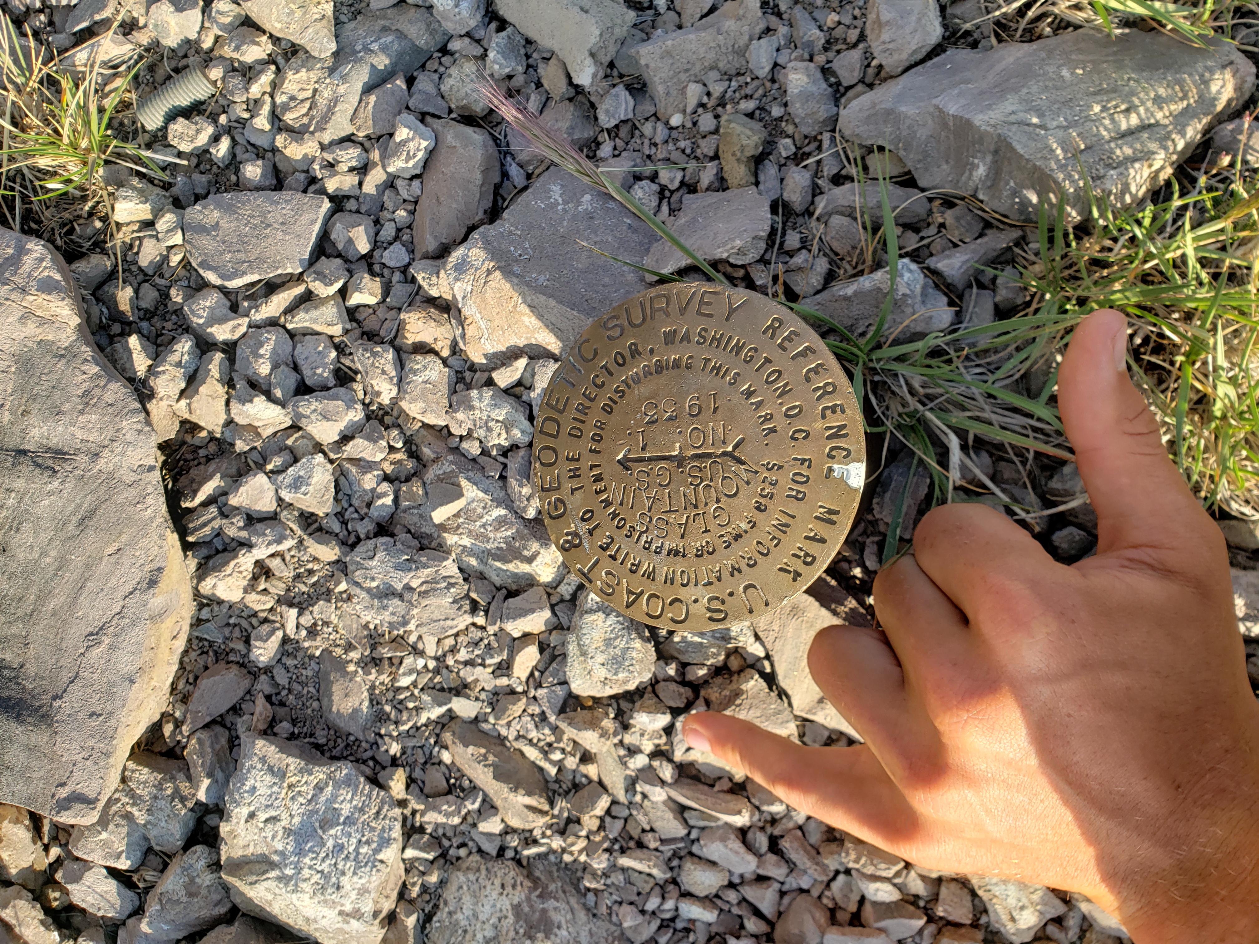 The Glass Mountain benchmark.
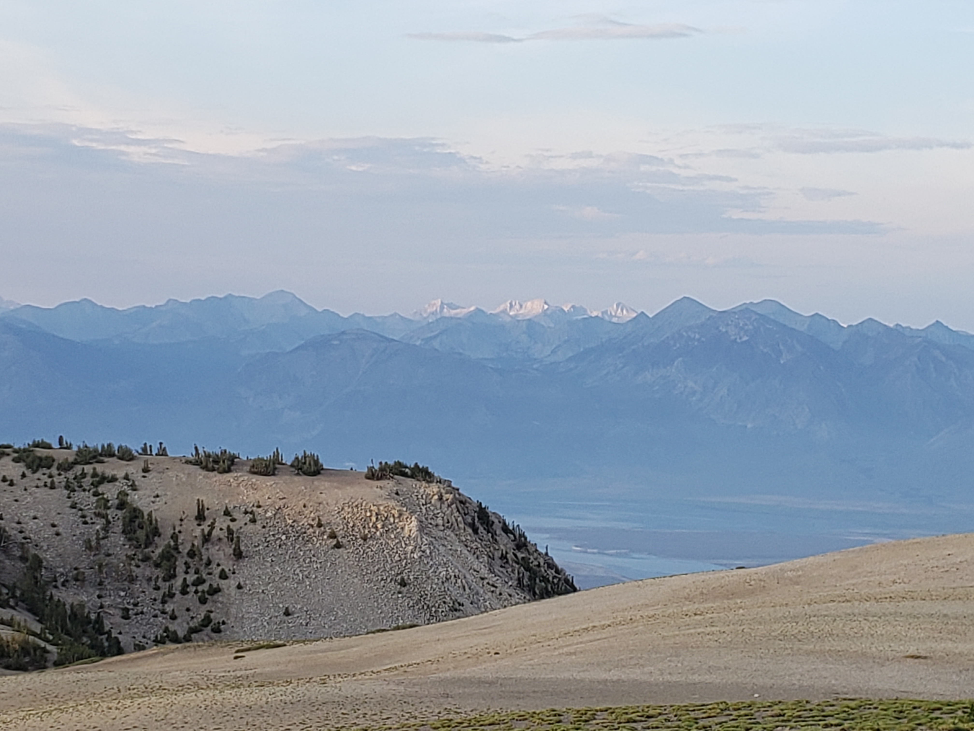 Looking south southwest three peaks were visible in the sun. Taking a look at Google Earth and using the ridge in the foreground to draw a line, I believe the peaks from right to left are Bear Creek Spire (which I climbed in 2018), Mt. Julius Caesar, Mt Gabb, and Mt Hilgard, although only Bear Creek Spire is distinctive enough to know for certain.
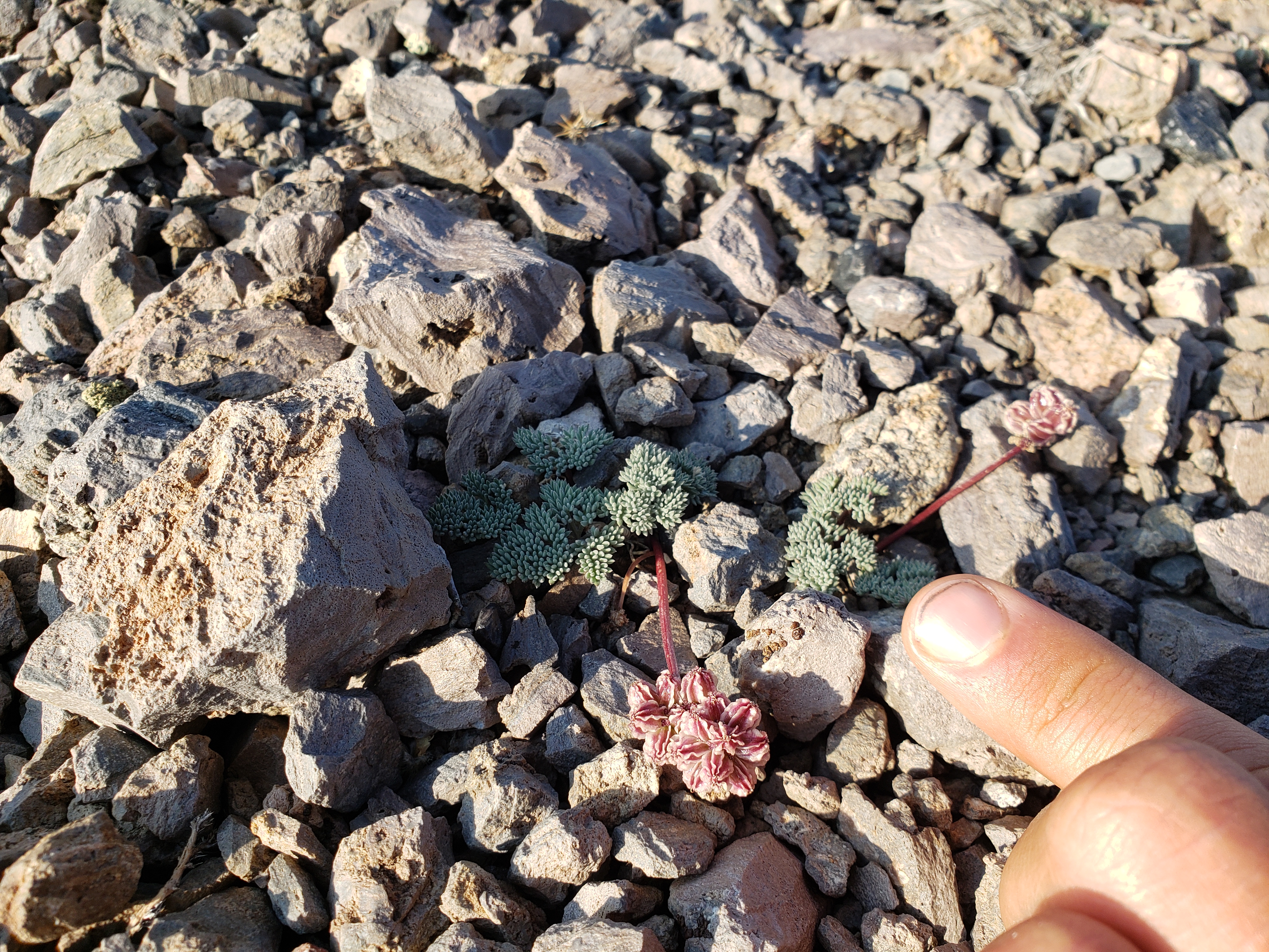 The special plant in question. I found this good one (I have better eyes).
.jpg) But my dad wanted a closer photo (credit to dad)
But my dad wanted a closer photo (credit to dad)
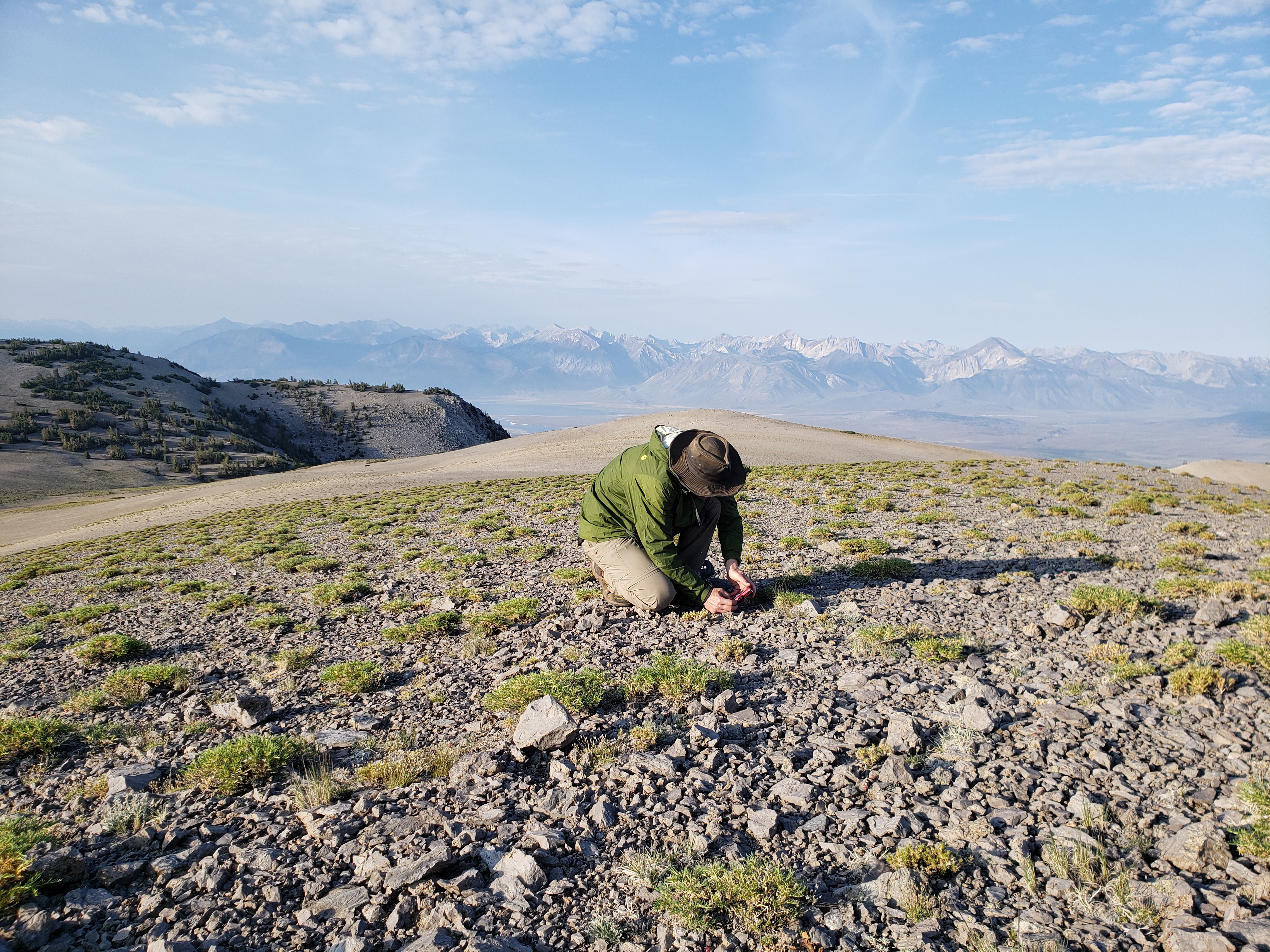 And here is the botanist in his natural habitat.
 While I much prefer the view. Here is a panorama looking southwest into the Long Valley Caldera and toward the Sierra Nevada.
 At the southern peak of the Glass Mountain plateau, now getting a better view down into Crowley Lake.
 And finally me, taking my last photo op before we head down and back home.